top of page
California: Northwards, to Big Surf and Big Trees (Jan. 2024)
A motto we have adopted on the road is, "Visit popular places at unpopular times." That's what we did in January 2024 when we left the mild temps of Orange County, CA (where we had returned from Arizona on New Year's Day) and headed north of Los Angeles. Our final destination would be the redwoods near the Oregon border, but en route to see these mammoth specimens of biomass we'd stop at various points of interest. Sticking close the Pacific and avoiding interstates, our preferred roadways would be Highways 1 and 101. The trip promised to be a loosey-goosey excursion--our favorite kind!
The benefits of going up north in California in January were many: uncrowded highways and no problem parking our 21-foot-long van, Morgan. Also welcome: ease in reserving campsites, even in state and national parks. Cool temperatures for comfortable hikes. Oh, and no flies or mosquitos!
The downside of our wintertime excursion: unpredictable weather. Bundling up at times to ward off cold and wind? Check. Having to turn the heat on in the van at night, and awakening to condensation on the windows from high humidity? Yes, indeed. Frequent rain, not usually the horizontal kind that douses campfires and sends everyone scurrying for shelter, but misty, enveloping moisture that spells Rain Slicker and bad hair days? Affirmative. Add to these meteorological challenges the road closures, street flooding, detours, and construction (winter being when coastal highway crews are active and roads are most likely to fail), and you might ask, Would we make this trip in January again? Heck, yes!
What follows are some of the highlights of our amazing journey to Central and Northern California. Hope you enjoy the pics!
California: Up the coast above Santa Barbara we go

Mission at Santa Barbara

Refugio State Beach, Goleta, CA: Like my hat?

Refugio SB: Camping in the sand with a full moon

Vandenberg, Lompoc: Starlink headquarters

Jalama County Park

Jalama County Beach, Goleta, CA

Jalama at low tide

Jalama Beach, Lompoc

Morro Bay

Jalama Beach camping

Jalama Beach

Morro Bay: Volcanic Morro Rock in background

Moonstone Beach, Cambria

Cambria: Rock on!

Elephant Seals at Piedras Blancas Point: Blubber for as far as the eye can see

Elephant Seal Beach: Those aren't rocks on the beach down there!


William Randolph Hearst Memorial Beach: Encountering a male elephant seal (8,000 lbs.?), this dog says, "Retreat!"


Big Sur: No highrises here
Enveloping fog at Salmon Creek, south of Big Sur: southern range of the redwoods

Carmel

Downtown Monterey

Highway 1 into Big Sur: The road just north of here was closed to all traffic (landslide)

Monterey: Surf's up!

Town of Rodeo on Monterey Bay: Tugboat sads

Bouquet, anyone? Gualala, CA

Point Arena Light, home of Arena Mina the cat

Point Arena Light's original First Order rotating Fresnel lens, now housed in their museum (weighs 6 tons!)

Point Arena Lighthouse grounds: We have an Arena Mina sighting!

Bigfoot sure gets around: General Store, Walsh Landing


Glass Beach, Fort Bragg, CA: Once a garbage dump, now a glittering shore

Seaside Beach, Mendocino County, north of Fort Bragg

Arched Rock Beach,Bodega Bay

San Simeon

"And a landslide brought me down" Highway 1 near Westport, CA

Pilot car guides traffic through a one-lane section of construction on Highway 1 near Westport, CA

Vintage Cowboy Winery (Harvest Host campsite), Santa Margarita, CA
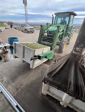
43 Ranch Olive Oil, San Ardo, CA: Olives heading to the press


43 Ranch Olive Oil, San Ardo (Harvest Host campsite): High above the olive groves


Pinnacles National Park, near Soledad, CA

Pinnacles NP

Dark Star Cellars, Paso Robles, CA (a Harvest Host site; we camped by the vines)

Karen and Olivier visit us at Dark Star Cellar, Paso Robles
In Search of the Big Trees


Richardson Grove State Park, Garberville, CA

Founders Grove, Humboldt State Park: This tree is dedicated to the founders of Save the Redwoods League, who likened felling ancient redwoods to "chopping up a grandfather's clock for kindling."

Root system of the Dyerville Giant, Founders Grove, Humboldt SP: When this 362-ft-high tree fell in a 1991 storm the impact registered on a seismograph


Burlington Campground, Humboldt SP: Our home for the night,
a massive redwood marking the site

Myers Flat, CA: Gateway to Humboldt State Park's Avenue of the Giants

Unnamed tree along the Avenue of the Giants, Humboldt SP


"Who's a good banana slug?" Sue-Meg SP

Prairie Creek Redwoods State Park lies within Redwoods National Park--a unique state/federal arrangement

Newton Drury Parkway, Prairie Creek SP: Closure of this major road through park for maintenance meant no crowds for us! Just hike it!

Herd of "Bachelor Elk," Elk Prairie Meadows, Prairie Creek SP: Couldn't form a harem so they'll loll around 'til next mating season

Big Tree Loop (Cathedral Tree and Karl Knapp Trails), Prairie Creek SP

Big Tree Loop, Prairie Creek SP

Cathedral Trees Trail, Prairie Creek SP

Rotary Memorial Grove, Foothill Trail, Prairie Creek SP: Rotary Clubs of California donated this 80-acre grove in 1952 for posterity

Iluvatar, (at center), the largest (300 ft) and oldest (1,687 yrs) redwood in Atlas Grove within Rotary Memorial Grove, Prairie Creek SP: Made famous by its inclusion in Richard Preston's book The Wild Trees, Iluvatar has 209 branches

Cathedral Trees Trail, Prairie Creek SP
bottom of page